
A massive cloud band stretching nearly 10,000 kilometres from northern India to South Korea has been captured in satellite images, drawing attention to an intense phase of the 2026 southwest monsoon. The giant weather formation, linked to active monsoon conditions across Asia, has brought widespread rainfall to several parts of India while raising questions about whether the country could see a stronger monsoon spell ahead
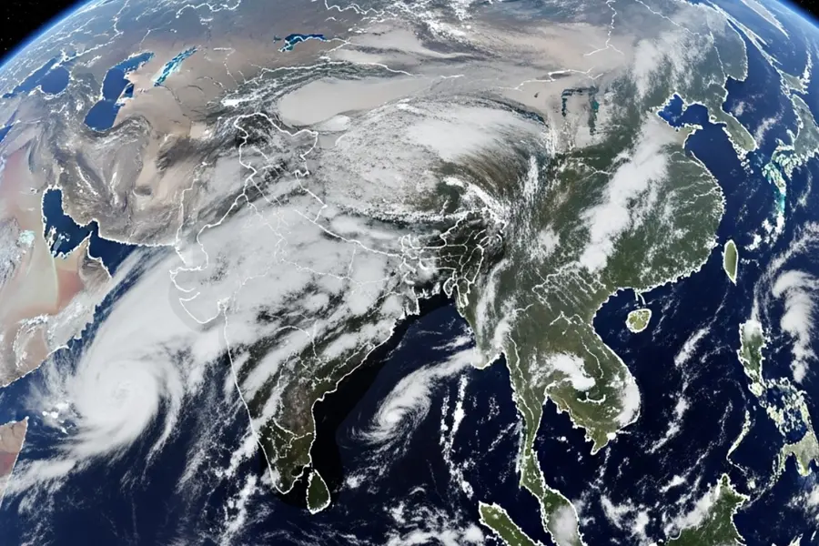
A massive monsoon cloud band stretching thousands of kilometres across Asia has been captured in satellite images, highlighting an active phase of the 2026 southwest monsoon and bringing widespread rainfall across several parts of India.
What is the 10,000-km rain cloud band?
Also Read

Satellite images have shown a huge belt of rain-bearing clouds extending from northern India through the Himalayan region, China and towards South Korea. While it appears like one continuous cloud system, meteorologists explain that it is actually a large zone of connected clouds formed by the Asian monsoon circulation.
The cloud band is created when moisture-filled winds from the Indian Ocean move inland and meet changing atmospheric conditions across Asia. As warm, humid air rises into the atmosphere, it cools and condenses, forming large cloud systems capable of producing widespread rainfall.
This type of weather pattern is known as a monsoon convergence zone, where different air flows meet and create strong upward movement of moisture, leading to heavy cloud formation and rain.
Why has this cloud band formed?
The current cloud formation is linked to an active southwest monsoon phase over India. Moisture from both the Arabian Sea and the Bay of Bengal is being transported inland, while low-pressure systems and atmospheric circulations are helping lift this moisture higher into the atmosphere.
The interaction of these weather systems has organised rainfall activity into a broad cloud corridor covering a large part of Asia.
However, experts clarify that the giant cloud band is not a single storm or one cloud travelling thousands of kilometres. It is a large-scale atmospheric pattern created by multiple connected weather systems.
ALSO READ | 10 acres of encroached land reclaimed in Vagamon; Prakash Raj also issued survey notice
Does the 10,000-km cloud mean a bumper monsoon?
The appearance of the cloud band indicates that conditions are favourable for widespread rainfall, but it does not automatically guarantee an above-normal monsoon season.
A strong cloud formation can bring intense rainfall over a short period, but the overall monsoon performance depends on several factors, including the movement of weather systems, ocean conditions and rainfall distribution across regions.
If the current active phase continues, it could help reduce rainfall deficits in areas that received less rain earlier in the season.
How is it affecting India?
The active monsoon spell has brought heavy rainfall to several states, including Uttar Pradesh, Uttarakhand, Punjab, Haryana, Delhi-NCR and parts of Rajasthan. Eastern and northeastern states have also witnessed intense rainfall due to additional weather systems moving inland.
The increased rainfall is expected to benefit agriculture, especially the kharif cropping season, by improving soil moisture and helping replenish water resources.
At the same time, very heavy rainfall has increased risks of flooding, waterlogging, landslides and river swelling, particularly in Himalayan states such as Uttarakhand and Himachal Pradesh.
Why does this matter?
The massive cloud band shows how interconnected Asia's weather systems are. The Indian monsoon is not an isolated regional event but part of a larger atmospheric circulation affecting weather patterns across a wide area.
Meteorologists use satellite monitoring of such cloud structures to improve rainfall forecasts and issue early warnings for extreme weather events.
For India, the current monsoon activity could bring much-needed rainfall to several regions, but authorities continue to monitor vulnerable areas because intense rainfall can also create significant risks.
Published: 23 Jul 2026, 10:05 pm IST
Related Topics
Disclaimer: Kindly avoid objectionable, derogatory, unlawful and lewd comments, while responding to reports. Such comments are punishable under cyber laws. Please keep away from personal attacks. The opinions expressed here are the personal opinions of readers and not that of Mathrubhumi.