
Hurricane Polo has exploded into a Category 5 hurricane off Mexico, with 180 mph winds and an exceptionally low central pressure. Forecasters are also watching its possible interaction with Tropical Storm Odalys.
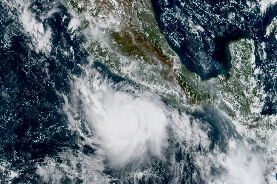
Hurricane Polo has rapidly intensified into an extremely dangerous Category 5 hurricane off Mexico's Pacific coast, with maximum sustained winds reaching 180 mph (285 kmph), while forecasters monitor its interaction with another tropical system, Tropical Storm Odalys.
Polo strengthened dramatically on Tuesday, September 22, becoming the third Category 5 hurricane of the 2026 eastern Pacific season. The National Hurricane Center said a NOAA Hurricane Hunter aircraft found maximum sustained winds of about 180 mph (285 kmph) and a minimum central pressure of 892 mb.
Also Read

The storm was located about 215 miles (345 km) south of Zihuatanejo, Mexico, and was nearly stationary. Forecasts indicated that Polo would move generally west-northwestward while remaining offshore, although its core was expected to track near the southwestern Mexican coast.
The National Hurricane Center described Polo as an "extremely dangerous" Category 5 hurricane. A tropical storm warning was issued for part of Mexico's southwestern coast.
Polo's rapid intensification surprises forecasters
What has made Polo particularly notable is how quickly it strengthened.
The National Hurricane Center said Polo intensified by about 90 knots in 24 hours, describing the rate of strengthening as "truly remarkable".
The storm went from a much weaker system to Category 5 strength in a remarkably short period. A NOAA Hurricane Hunter aircraft was sent into the storm to obtain more accurate measurements of its strength and structure.
The latest aircraft observations found an exceptionally low central pressure of 892 mb, a measurement associated with an exceptionally intense tropical cyclone.
Mexico faces flooding, mudslides and dangerous surf
Although Polo was forecast to remain offshore, Mexico's Pacific coast remained at risk from heavy rain, strong winds, large swells and dangerous ocean conditions.
The National Hurricane Center forecast 4 to 8 inches of rain, with isolated totals of up to 12 inches, across coastal portions of Guerrero and Michoacán through Thursday. Heavy rainfall could trigger life-threatening flooding and mudslides, particularly in mountainous areas.
Coastal areas of Oaxaca, Colima and Jalisco could also receive several inches of rain. Large swells generated by Polo were expected to create dangerous surf and rip-current conditions.
Mexican authorities took precautionary measures, including suspending classes in some areas and closing ports in Guerrero and Michoacán.
Why Polo is being compared with major Pacific storms
Polo's intensity has drawn comparisons with some of the strongest storms observed in the eastern Pacific.
Its maximum winds were approaching the range seen in only a small number of exceptionally intense storms in the region. Hurricane Patricia, which reached an estimated 215 mph in 2015, remains one of the most extreme examples.
The University at Albany atmospheric scientist Kristen L. Corbosiero described Polo as one of the strongest storms ever observed in the Pacific basin.
Polo and Odalys could create a rare interaction
Polo is not the only tropical system being watched in the Pacific.
Tropical Storm Odalys was also moving across the Pacific, and forecasters were monitoring the possibility that the two systems could come close enough to influence each other's movement.
Such an interaction is known as the Fujiwhara effect. It occurs when two nearby tropical cyclones begin rotating around a common centre, potentially changing the track and speed of one or both systems.
The National Hurricane Center said increasing uncertainty in the forecast later in the week could be linked to Polo's potential interaction with Odalys.
Hawaii also faces another weather threat
The wider Pacific basin has remained unusually active. A separate area of disturbed weather associated with the remnants of Tropical Depression Fifteen-E was being monitored near Hawaii.
Forecasters said environmental conditions could allow the system to redevelop. Heavy rainfall was possible across parts of the Big Island even if the system did not become a named storm.
This means the Pacific is dealing with several separate tropical-weather threats while Polo remains the dominant system.
Polo's moisture could affect the US Southwest
Polo's influence is also extending beyond Mexico.
Moisture associated with the hurricane was being drawn northwards towards the US Southwest, increasing the potential for heavy rainfall in parts of New Mexico.
Forecasts called for several inches of rain in parts of the state, with locally higher amounts possible.
What is happening in the Atlantic?
The situation in the Pacific contrasts sharply with the Atlantic hurricane season.
According to the report, the Atlantic had not yet produced a hurricane this season, while the Pacific had already produced multiple Category 5 systems.
Meteorologists have linked the contrasting activity to the prevailing large-scale climate pattern, including El Niño, which can affect ocean temperatures and atmospheric winds differently across the two basins.
Why Hurricane Polo matters
Polo's rapid intensification is the central feature of the current storm. It strengthened extremely quickly while remaining offshore, leaving authorities with a limited window to prepare for the possibility of dangerous weather along Mexico's Pacific coast. The National Hurricane Center's observations confirm that the storm reached Category 5 intensity and had an exceptionally low central pressure.
The storm also highlights why a hurricane does not need to make direct landfall to pose a serious threat. Heavy rainfall can trigger flooding and mudslides, while large swells and rip currents can create dangerous coastal conditions.
The possible interaction between Polo and Odalys adds another layer of uncertainty because the Fujiwhara effect can alter the movement of tropical cyclones. Forecasters are therefore monitoring not only Polo's strength but also its future track and relationship with surrounding weather systems.
Published: 23 Sept 2026, 07:46 am IST
ABOUT THE AUTHOR
Related Topics
Disclaimer: Kindly avoid objectionable, derogatory, unlawful and lewd comments, while responding to reports. Such comments are punishable under cyber laws. Please keep away from personal attacks. The opinions expressed here are the personal opinions of readers and not that of Mathrubhumi.