
The UN’s ‘Correct the Map’ resolution backs equal-area projections like Equal Earth. Here’s why India and South Asia appear larger than on Mercator maps.
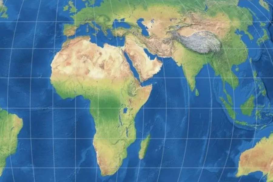
When the United Nations General Assembly voted 164–1 on Friday to endorse a new “Correct the Map” standard, the loudest headlines focused on Africa. But for India and its neighbours, the resolution carries a quieter yet significant implication: under the UN‑backed Equal Earth projection, the Indian subcontinent appears visibly larger and more proportionate than on the familiar Mercator maps that have dominated classrooms, newsrooms and apps for generations.
The change does not alter borders, population or economic data. It does, however, shift the mental map of a generation -- and with it, the perceived geopolitical and economic heft of South Asia.
What changes for India on the new map
The Mercator projection, designed in 1569 for navigation, preserves angles and directions but badly distorts area as you move away from the Equator.
Landmasses at higher latitudes -- Europe, Russia, Canada, the northern United States -- look oversized, while equatorial and low‑latitude regions, including much of Africa, South America and South Asia, look smaller than their true share of the planet’s land area.
ALSO READ: Africa bigger, West smaller: How a UN map vote will reshape global order
Equal Earth, the equal‑area projection championed in the UN resolution, is built to preserve relative surface area while keeping shapes recognisable. Cartographers Bojan Šavrič, Bernhard Jenny and Tom Patterson launched it in 2018 precisely to address these distortions.
Under Equal Earth, Africa, Latin America, South Asia and Oceania appear “vastly larger” compared with Mercator, because their true area is no longer compressed by the projection.
India and the wider Indian subcontinent -- stretching from Afghanistan in the northwest to Myanmar in the east, and down to Sri Lanka and the Maldives -- gain visual prominence relative to Europe and the northern landmasses.
Regions like Europe, Russia and the northern US shrink back toward their actual proportional size.
As one summary put it, Equal Earth “makes Africa, Latin America, South Asia and Oceania appear vastly larger,” correcting a centuries‑old bias that made “the United States, Russia and China take on a disproportionate visual prominence compared to Africa, Latin America or southeast Asia.”
In practical terms, India does not “grow” in square kilometres; it simply looks closer to its true relative size on a sphere. But after decades of Mercator‑style visuals, that adjustment is striking enough to be noticed at first glance.
ALSO READ: India officially maps 27 Arunachal sites to counter China's ‘preposterous’ renaming spree
Why India’s visual upgrade matters
For Indian policymakers, educators and strategists, the map shift intersects with several ongoing narratives: India’s rise as a demographic and economic powerhouse, its claim to leadership of the Global South, and its push for a reformed, more representative multilateral order.
1. A stronger visual anchor for “Global South leadership”
India has positioned itself as a voice of the Global South in forums ranging from the G20 to climate negotiations. A map that shows South Asia in truer proportion reinforces that claim visually: the subcontinent no longer looks like a mid‑sized appendage squeezed between a bloated Europe and an oversized Russia, but as a substantial landmass carrying 1.8–2 billion people across multiple countries.
That matters in classrooms and media as much as in diplomatic briefing rooms. As the UN resolution notes, maps “guide education, nourish the imagination, and influence collective perceptions.” A child in Mumbai, Nairobi or Brasília growing up with Equal Earth will internalise a different sense of where the world’s weight lies.
2. Reframing India-Europe and India-Russia comparisons
On Mercator, Europe can look disproportionately large relative to South Asia, and Russia can dominate the northern half of the map. Equal Earth compresses those high‑latitude landmasses and expands equatorial ones, subtly rebalancing how students and viewers compare:
India vs Europe: The subcontinent’s area looks more commensurate with its population and economic scale, rather than visually subordinate to a seemingly larger Europe.
India vs Russia: Russia’s sheer east-west sweep remains, but its area no longer overwhelms the map to the same degree, allowing South Asia’s density and centrality in the Indo‑Pacific to stand out more clearly.
For strategic communicators, this supports narratives about the Indo‑Pacific as the centre of gravity, rather than a peripheral zone off the edge of a Euro‑centric map.
3. Classroom impact: decolonising geography in India
India’s own geography curriculum has long used a mix of projections, with many school wall maps still Mercator‑based or derived from it. The UN resolution does not mandate changes, but it gives education boards, textbook publishers and ed‑tech platforms a clear international reference point to justify moving toward equal‑area maps where relative size matters.
For Indian educators already debating how to “decolonise” curricula and present a more Global South‑centric worldview, Equal Earth offers a technically sound, visually compelling tool. It aligns with efforts to show students that India and its neighbours occupy a large, central slice of the inhabited world, not a marginal corner.
ALSO READ: Indian diplomat Pooja Jha draws praise for red-flagging map showing J&K as part of Pakistan | WATCH
What the UN resolution actually says about regions like South Asia
The text of the “Correct the Map” resolution explicitly links the Mercator distortion to the under‑representation of equatorial regions. It argues that the traditional map “significantly understates Africa’s actual size” and, by extension, similarly compresses other low‑latitude regions, including South Asia.
While Africa is the political spearhead of the campaign, the resolution’s language is broader: it promotes equal‑area projections to achieve “equitable representation of the world’s regions,” not just one continent.
Multiple reports summarising the vote note that Equal Earth makes “South Asia” appear vastly larger, grouping India, Pakistan, Bangladesh, Sri Lanka and neighbours with Africa and Latin America as regions whose visual weight has been suppressed by Mercator.
What does not change -- and where caution is needed
Officials and cartographers stress that the UN move is symbolic and advisory, not a ban on Mercator. The resolution does not alter borders or sovereignty claims. India’s boundaries with Pakistan, China, Nepal, Bangladesh and Myanmar remain defined by treaties and maps recognised by states, not by projection choice.
ALSO READ: Can India stop a hazardous asteroid? Expert outlines why preparedness is crucial
Does not replace Mercator for navigation. Mercator’s strength -- preserving direction and angles -- keeps it relevant for certain technical uses, even as equal‑area maps become preferred for education and general reference.
Requires careful use in disputed areas. As Ukraine warned during the debate, any map change can be exploited in propaganda if it introduces ambiguity around occupied or contested territories.
For India, this underscores the need to ensure that new classroom and official maps clearly reflect its position on Jammu & Kashmir, Arunachal Pradesh and other sensitive areas, regardless of projection.
How Indian media, schools and tech may respond
In the weeks and months ahead, several scenarios are likely:
- Textbook publishers and state boards may begin piloting Equal Earth or other equal‑area maps in social science and geography textbooks, especially for classes focused on “world geography” and “India and the world.”
- News channels and digital outlets may adopt Equal Earth for graphics comparing countries’ land area, population density or climate vulnerability, where accurate relative size is important.
- Ed‑tech and map apps operating in India could add an “Equal Earth” or “True Size” mode, marketed as aligned with UN guidance and better for learning.
- Given India’s deep engagement with both Global South solidarity and great‑power competition, the new map offers a rare win‑win: it visually bolsters the Global South narrative without diminishing India’s own stature.
A bigger India on the map, but the real test is policy
The UN’s map reform will not move mountains, change trade flows or shift military balances. But maps are not neutral; they shape how people imagine power, opportunity and belonging.
ALSO READ: What scientists found beneath the Bermuda Triangle could rewrite Earth science
For a country that sees itself as an emerging pole in a multipolar world, a projection that shows the Indian subcontinent in truer proportion is more than a cartographic tweak -- it is a subtle reinforcement of India’s self‑image as a central, not peripheral, player.
As the UN debate made clear, the question now is not whether the Earth has changed shape, but whether governments, schools and media will let a 16th‑century navigation tool continue to define the 21st‑century mental map.
For India, the “Correct the Map” vote is an invitation to redraw that mental map -- starting with how the subcontinent sees itself.
Published: 05 Sept 2026, 12:41 pm IST
ABOUT THE AUTHOR

Related Topics
Disclaimer: Kindly avoid objectionable, derogatory, unlawful and lewd comments, while responding to reports. Such comments are punishable under cyber laws. Please keep away from personal attacks. The opinions expressed here are the personal opinions of readers and not that of Mathrubhumi.