The Centre has strongly defended the Great Nicobar Island Development Project, calling it a “strategic national asset” amid sharp criticism from Rahul Gandhi and environmental concerns.
The Indian government is firmly defending the Great Nicobar Island Development Project, dismissing Opposition leader Rahul Gandhi's accusations of a "scam" and "crime against nature" as politically-motivated exaggerations.
The project - envisioned as a transformational infrastructure hub in the Andaman Sea - is being portrayed by the Centre as a "strategic national asset" that balances port‑led growth, ecological protection, and the welfare of indigenous communities, while simultaneously bolstering India’s maritime posture in the Indo‑Pacific.
Also Read

Gandhi, who visited the Andaman and Nicobar Islands from April 26 to 28, claimed that the project would involve the clearance of 160 sq km of rainforest and described it as "destruction dressed in the language of development". He accused the government of green‑washing a "biggest scam" and vowed to raise the matter in Parliament.
The Union Ministry of Environment, in turn, has issued a detailed rebuttal via the Press Information Bureau (PIB). The ministry asserts that the Great Nicobar Project is not only legally compliant but also "strategically indispensable" for India's maritime and economic future. It underscores that the development is guided by a "sensitive and holistic approach" that integrates environmental safeguards and tribal‑welfare measures into every phase of implementation.
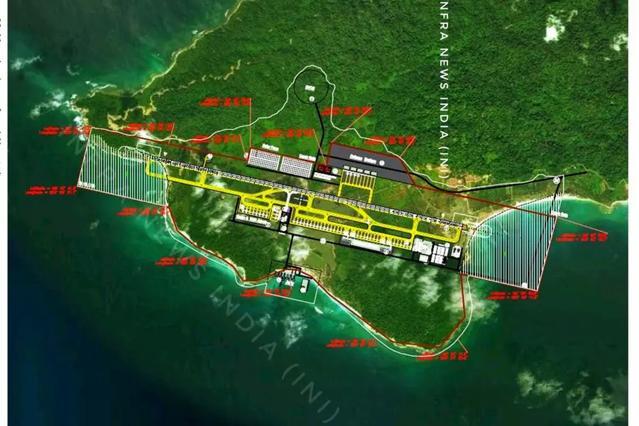
Core infrastructure components
The Great Nicobar project envisages four major components:
* International Container Transhipment Terminal (ICTT) at Galathea Bay, with a design capacity of 14.2 million TEUs (Twenty‑Foot Equivalent Units), to serve as a deep‑water hub for gateway and transhipment cargo. India currently loses substantial port revenue because large vessels cannot berth at Indian ports, forcing rerouting through Colombo and Singapore.
* A Greenfield International Airport, designed to handle 4,000 peak‑hour passengers, with a final capacity target of around 10 million passengers per year. The facility is expected to position Great Nicobar as a tourism gateway to the region, drawing parallels with nearby international destinations such as Phuket, Langkawi, and Penang.
* A new township spanning 166.10 sq km, housing 130.75 sq km of forest land and 35.35 sq km of revenue land, to support residential, commercial, institutional, and service‑provider needs arising from the port‑led economy.
* A 450‑MVA gas and solar‑based power plant, to replace the islands' heavy dependence on diesel‑powered generators and ensure uninterrupted, high‑quality power supply for the port, airport, township, and future industrial activities.
Strategic and Economic Rationale
The project is being implemented in three phases:
- Phase I (2025–35): 72.12 sq km
- Phase II (2036–41): 45.27 sq km
- Phase III (2042–47): 48.71 sq km
The phased rollout allows for systematic infrastructure development while ensuring that environmental safeguards and tribal‑welfare mechanisms are embedded at each stage.
Geopolitically, Great Nicobar lies just about 150 km from the Strait of Malacca, which carries roughly 25–30 per cent of global maritime trade and supplies about 75 per cent of China's energy imports. The transhipment port, airfield, and defence‑enclave components are seen as critical for enhancing "maritime domain awareness", projecting naval and air power, and reinforcing India’s presence in the eastern Indian Ocean and western Indo‑Pacific.
Economically, the project aims to reduce India’s dependence on foreign transhipment hubs and to capture a share of the growing container traffic in the Indo‑Pacific trade corridor.
Planners argue that the ICTT at Galathea Bay - with its natural water depth of over 20 metres - has the potential to emerge as a competitive alternative to Colombo and Singapore for regional trade.
Environmental impact and safeguards
The project received prior Environmental Clearance under the Environmental Impact Assessment (EIA) Notification, 2006, following a multi‑stage process of screening, scoping, public consultation, and expert appraisal. The clearance includes 42 specific conditions covering air, water, noise, waste management, marine ecology, human health, and disaster‑risk management, along with a comprehensive Environment Management Plan (EMP).
According to the government, independent studies were conducted by institutions such as the Zoological Survey of India (ZSI), Salim Ali Centre for Ornithology and Natural History (SACON), Wildlife Institute of India (WII), and the Indian Institute of Science (IISc). The ZSI, in particular, concluded that the project could proceed with “appropriate environmental safeguards” in place.
Approximately 1.82 percent of the total forest cover of the Andaman and Nicobar Islands is proposed to be diverted for the project, amounting to about 18.65 lakh trees, of which roughly 7.11 lakh may be felled across 49.86 sq km of forest over the project’s lifespan.
To offset this, 65.99 sq km will be preserved as green zones, and compensatory afforestation is being planned on 97.30 sq km of land in Haryana for Phase I. As part of the “Ek Ped Maa Ke Naam” initiative, over 2.4 million trees have already been planted in the Union Territory.
Protection of Indigenous Communities
Great Nicobar is home to two Particularly Vulnerable Tribal Groups (PVTGs): the Shompen (about 237 individuals) in the interior forests and the Nicobarese (about 1,094 people) along the coast. The project has been explicitly designed to avoid displacement of tribal communities. The only tribal habitations falling within the project area are New Chingen and Rajiv Nagar, and the administration has stated that no relocation is proposed.
The project is aligned with the Shompen Policy, 2015 and the Jarawa Policy, 2004, both of which mandate that large‑scale development projects must prioritize the integrity and welfare of PVTGs. The Ministry of Environment has mandated an Independent Monitoring Committee to oversee issues affecting the Shompen and Nicobarese; consultations have also been held with the Ministry of Tribal Affairs, the Directorate of Tribal Welfare, the Andaman Adim Janjati Vikas Samiti (AAJVS), and anthropological experts.
Currently, about 751.07 sq km of the island is marked as Tribal Reserve. Of the 166.10 sq km earmarked for development, 84.10 sq km overlaps with this reserve. However, 11.032 sq km within this overlap has already been used as revenue land since 1972; the remaining 73.07 sq km is being de‑notified for the project.
In compensation, 76.98 sq km will be re‑notified as Tribal Reserve, leading to a net addition of 3.912 sq km of tribal‑protected land. In Phase I, only 40.01 sq km of tribal area is involved, of which 11.032 sq km is already under revenue use.
Risk assessment and disaster management
The island lies in a seismically sensitive and cyclone‑prone region, having experienced severe damage during the 2004 Indian Ocean earthquake and tsunami. A comprehensive risk‑assessment study has been conducted, covering natural hazards such as tsunamis, earthquakes, and cyclones, as well as anthropogenic risks like industrial accidents.
A detailed vulnerability and disaster‑management plan has been prepared, and the hybrid gas‑solar power plant is designed to enhance resilience by reducing dependence on single‑source generation and cutting carbon emissions.
The National Green Tribunal (NGT) upheld the environmental clearance in February 2026, observing that the project is of “strategic importance” and that there are “adequate safeguards” in place. The tribunal found “no good ground” to interfere with the existing clearance, although it directed strict compliance with environmental conditions.
The government positions the Great Nicobar Project as a model for integrating economic growth, ecological conservation, and social inclusion in an ecologically sensitive geography.
By committing to wildlife protection, compensatory afforestation, disaster preparedness, and robust tribal‑welfare mechanisms, the Centre argues that the project demonstrates that “economy and ecology” can reinforce, rather than undermine, each other.
Yet the project remains contentious, with environmentalists and indigenous‑rights groups warning that even limited tree felling, habitat fragmentation, and increased human activity could irreversibly affect the island’s UNESCO‑recognized biodiversity and fragile ecosystems.
Published: 01 May 2026, 08:17 pm IST
Related Topics
Disclaimer: Kindly avoid objectionable, derogatory, unlawful and lewd comments, while responding to reports. Such comments are punishable under cyber laws. Please keep away from personal attacks. The opinions expressed here are the personal opinions of readers and not that of Mathrubhumi.