
Heavy to very heavy rainfall is anticipated across Tamil Nadu from Friday onwards, especially in delta districts.
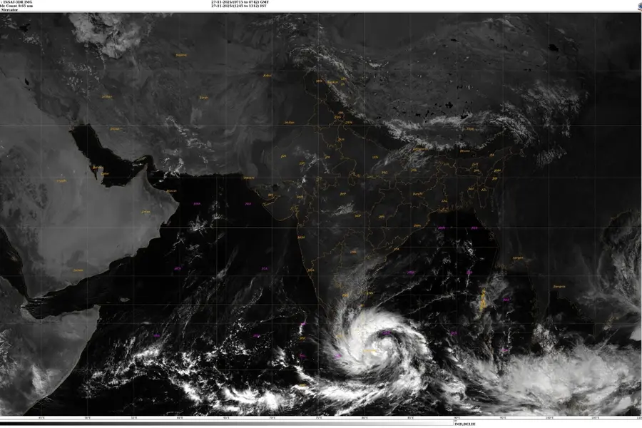
Chennai: A deep depression forming over the southwest Bay of Bengal and adjoining Sri Lanka coast intensified on Thursday, with meteorologists forecasting it will strengthen into a cyclonic storm by evening.
The Regional Meteorological Centre (RMC) predicted the system will track north-northwestwards across the southwest Bay and Sri Lankan coastline towards north Tamil Nadu, Puducherry, and adjoining south Andhra Pradesh coast by Saturday. Upon reaching cyclonic intensity, it will be christened 'Cyclone Ditwah,' a name suggested by Yemen from the World Meteorological Organisation (WMO) and UN Economic and Social Commission for Asia and the Pacific (UN-ESCAP) tropical cyclone list.
The RMC maintained its earlier alert for heavy rainfall over south Tamil Nadu and delta districts on Thursday, with a marked escalation statewide from Friday. Delta and nearby districts face heavy to very heavy showers on Friday, while heavy rain will extend to north Tamil Nadu on Saturday as the system advances along the coast.
Rainfall eased notably on Wednesday after prolonged downpours in southern districts. In the 24 hours to 8:30 a.m. Thursday, only isolated light showers occurred, with Thangachimadam in Ramanathapuram recording the highest at 3 cm and Oothu in Tirunelveli at 1 cm.
In anticipation of further intensification, the RMC recommended raising storm warning signals at major ports, including Chennai, Cuddalore, Ennore, Thoothukudi, Nagapattinam, and Karaikal. Mariners were warned against entering the southwest Bay of Bengal and adjacent waters until further notice.
Isolated light rain is likely over Kanniyakumari, Thoothukudi, and Tirunelveli districts as the deep depression organises over the sea. Separately, Cyclone Senyar, centred over northeast Indonesia's coastal areas and the Strait of Malacca, will drift eastwards while sustaining cyclonic strength but poses no risk to Tamil Nadu, the RMC clarified.
With inputs from IANS
Published: 27 Nov 2025, 04:03 pm IST
Related Topics
Disclaimer: Kindly avoid objectionable, derogatory, unlawful and lewd comments, while responding to reports. Such comments are punishable under cyber laws. Please keep away from personal attacks. The opinions expressed here are the personal opinions of readers and not that of Mathrubhumi.
