
Severe Cyclone Akvan is heading towards the Andhra Pradesh coast, with landfall expected on November 20. Six coastal districts face possible flooding, while Chennai and neighbouring Tamil Nadu districts are on rain alert.
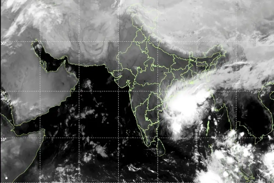
Amaravati: Cyclone Akvan has intensified into a severe cyclonic storm over the Bay of Bengal, putting coastal Andhra Pradesh on alert ahead of its expected landfall on November 20. While six coastal districts face the threat of storm surges and flooding, Chennai and neighbouring parts of Tamil Nadu are also likely to receive rainfall as the system moves slowly towards the eastern coast.
Severe Cyclone Akvan has intensified over the Bay of Bengal, prompting Andhra Pradesh to step up preparations for its expected landfall on November 20. The India Meteorological Department (IMD) has warned of powerful winds, heavy rainfall and possible flooding in vulnerable coastal areas.
According to the IMD's November 18 bulletin, the cyclone was moving north-northwestwards at around 3 kmph. At 5.30 am, it was located approximately 610 km southeast of Machilipatnam and 610 km south-southeast of Visakhapatnam.
The slow movement of the weather system has raised concerns about prolonged rainfall across parts of Andhra Pradesh and Tamil Nadu.
When and where will Cyclone Akvan make landfall?
The IMD has forecast that Cyclone Akvan will cross the Andhra Pradesh and Yanam coasts between Nellore and Visakhapatnam around noon on November 20.
The system is expected to make landfall as a severe cyclonic storm.
The IMD's forecast summary indicates maximum sustained wind speeds of 100-110 kmph, with gusts reaching 120 kmph. Its coastal warning, however, indicates that winds could reach 120-130 kmph, with gusts of up to 145 kmph, from the night of November 19 until landfall.
Coastal Andhra Pradesh and Yanam are likely to experience heavy to very heavy rainfall on November 19 and 20, with isolated extremely heavy rainfall.
Six Andhra districts face storm surge and flooding risk
The IMD has warned of a possible storm surge of 1-2 metres above the normal tide level.
Low-lying areas in the following six districts could face inundation:
- Prakasam
- Bapatla
- Krishna
- West Godavari
- Konaseema
- Kakinada
The combination of heavy rainfall, strong winds and rising sea levels could disrupt normal life in vulnerable coastal settlements.
Andhra Pradesh steps up cyclone preparations
Chief Minister N Chandrababu Naidu has directed district administrations to strengthen preparedness measures ahead of the cyclone's arrival.
The state is positioning National Disaster Response Force (NDRF) and State Disaster Response Force teams in vulnerable locations. Authorities have also been instructed to keep electricity restoration teams ready and maintain sufficient stocks of poles, transformers and conductors to deal with possible power disruptions.
The government is monitoring 30,808 registered fishing boats along Andhra Pradesh's 1,053-km coastline. Officials are working to bring the remaining vessels ashore, while more than 1.08 lakh voice alerts have been issued to fishing communities.
Farmers have been advised to harvest mature crops early and clear drainage channels to reduce waterlogging and potential crop damage.
The IMD has also advised fishermen not to venture into the Bay of Bengal until conditions improve, warning that sea conditions could become extremely rough to phenomenal near the Andhra Pradesh coast.
Chennai and neighbouring Tamil Nadu districts face rainfall
Although Cyclone Akvan is expected to make landfall along the Andhra Pradesh coast, its influence is likely to extend into neighbouring Tamil Nadu.
The IMD has forecast rainfall in Chennai and several surrounding districts on November 18 and 19.
November 18 (Wednesday):
- Chennai, Tiruvallur and Chengalpattu may receive moderate rainfall, accompanied by thunderstorms, lightning and strong winds at isolated places.
- Parts of southern Tamil Nadu, other northern coastal districts, Puducherry and Karaikal may experience light rainfall with thunderstorms and lightning.
- The remaining parts of Tamil Nadu are likely to experience predominantly dry weather.
November 19 (Thursday):
- Chennai and Tiruvallur may receive heavy rainfall at isolated places, accompanied by thunderstorms, lightning and strong winds.
- Chengalpattu, Kancheepuram, Villupuram and Cuddalore may experience light rainfall with thunderstorms and lightning.
- Most other parts of Tamil Nadu, Puducherry and Karaikal are likely to remain largely dry.
- The Chennai Meteorological Centre has indicated that rainfall could continue in parts of Tamil Nadu until November 23.
- Fishermen have been advised not to venture into the sea until further notice.
Why Cyclone Akvan is being closely monitored
Cyclone Akvan is approaching the eastern coast during an active period of the Northeast Monsoon. The previous cyclones Arnab and Murasu also crossed the Andhra Pradesh coast but brought widespread rainfall to parts of Tamil Nadu.
Akvan is expected to have a similar influence, with rainfall extending beyond the region where the cyclone is forecast to make landfall.
Its slow movement, projected wind speeds and potential storm surge make preparations particularly important for coastal communities.
Why Cyclone Akvan's slow movement matters
Cyclone intensity is not the only factor that determines the extent of its impact. The speed at which a storm moves also matters because a slowly moving system can expose certain areas to prolonged periods of rainfall and strong winds.
For Andhra Pradesh, the immediate concerns include coastal flooding, storm surges, damage to infrastructure, power disruptions and risks to fishing communities. The possibility of extremely heavy rainfall also raises concerns about waterlogging and agricultural losses.
Tamil Nadu faces a different but related challenge. Even though the projected landfall is along Andhra Pradesh, Chennai and neighbouring districts could experience rainfall and thunderstorms as the cyclone influences weather conditions over the region.
The approaching storm also places pressure on disaster management systems during the Northeast Monsoon, when several parts of southern India are already vulnerable to heavy rainfall.
The effectiveness of evacuation arrangements, fishing restrictions, early-warning systems and emergency response measures will be important in limiting the potential impact.
Published: 18 Nov 2026, 11:11 am IST


ABOUT THE AUTHOR

Related Topics
Disclaimer: Kindly avoid objectionable, derogatory, unlawful and lewd comments, while responding to reports. Such comments are punishable under cyber laws. Please keep away from personal attacks. The opinions expressed here are the personal opinions of readers and not that of Mathrubhumi.