
Cyclone Akvan is expected to bring heavy to extremely heavy rainfall across seven states, with Tamil Nadu, Odisha, West Bengal and Andhra Pradesh among the regions facing weather warnings.
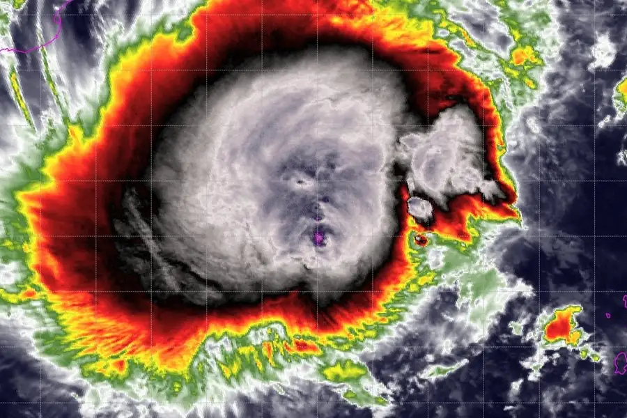
The India Meteorological Department (IMD) has warned of heavy to extremely heavy rainfall across several states as Cyclone Akvan intensifies over the Bay of Bengal.
The storm is expected to cross the Andhra Pradesh and Yanam coasts around noon on November 20, with wind speeds reaching 130 kmph and gusts of up to 145 kmph.
The approaching cyclone has triggered weather alerts across eastern and southern India, with Andhra Pradesh, Tamil Nadu, Odisha, West Bengal, Telangana, Jharkhand and Chhattisgarh among the states expected to experience adverse weather conditions over the coming days.
According to the IMD's National Bulletin No. 12, issued at 5:45 am on Tuesday, November 17, Cyclone Akvan remained practically stationary over the central parts of the south and adjoining west-central Bay of Bengal during the preceding nine hours. The system was centred near latitude 12.2°N and longitude 85.7°E.
It was located approximately 610 km east of Chennai, 660 km southeast of Machilipatnam, 670 km south-southeast of Visakhapatnam and 790 km south of Gopalpur in Odisha.
The IMD expects the cyclone to intensify into a severe cyclonic storm by Tuesday evening and further strengthen into a very severe cyclonic storm around the morning of November 19.
Continuing its northwestward movement, the storm is likely to cross the Andhra Pradesh and Yanam coasts between Nellore and Tuni around noon on November 20. The maximum sustained wind speed is expected to reach 120-130 kmph, with gusts touching 145 kmph.
Cyclone Akvan: Which states will receive heavy rainfall?
The IMD has forecast widespread rainfall across several states as the cyclone approaches the eastern coastline.
- Andhra Pradesh: Coastal Andhra Pradesh is expected to experience heavy to very heavy rainfall on November 19 and 20. Isolated extremely heavy rainfall, exceeding 204 mm in 24 hours, is also likely. Coastal districts face the greatest threat from the approaching system, particularly as strong winds are expected at landfall.
- Tamil Nadu and Puducherry: Heavy rainfall is forecast at isolated places on November 17, followed by heavy to very heavy rainfall across parts of Tamil Nadu, Puducherry and Karaikal on November 18 and 19. Northern coastal districts are likely to experience adverse weather conditions as the cyclone moves closer to Andhra Pradesh.
- Odisha: Heavy to very heavy rainfall is likely at isolated places between November 19 and 21. Southern Odisha districts are expected to be particularly vulnerable, with authorities preparing for possible flooding and landslides.
- West Bengal: Gangetic West Bengal is likely to receive heavy rainfall at isolated places on November 19 and 20. The approaching weather system could also trigger thunderstorms and gusty winds in parts of the state.
- Telangana: Eastern Telangana is likely to receive heavy rainfall on November 20, with the possibility of further rainfall on November 21.
- Jharkhand: Heavy rainfall is forecast at isolated places on November 20 and 21.
- Chhattisgarh: Southern districts could receive heavy rainfall on November 20, with similar conditions possible in northern parts of the state on November 21.
Storm surge warning for six Andhra Pradesh districts
Apart from heavy rainfall and high-speed winds, the IMD has warned of possible coastal inundation during landfall.
A storm surge of 1-2 metres above the astronomical tide is likely to affect low-lying coastal areas of Prakasam, Bapatla, Krishna, West Godavari, Konaseema and Kakinada districts.
The peak storm surge is expected over Bapatla, Krishna and West Godavari districts between the morning and afternoon of November 20.
The IMD has warned that the cyclone could damage thatched houses, uproot trees, snap electricity and communication lines, damage standing crops and disrupt road and transport infrastructure.
Odisha deploys 74 rescue teams, begins evacuation
Meanwhile, Odisha has stepped up its disaster preparedness as the cyclone approaches the eastern coastline.
The state government has deployed 74 rescue teams and initiated early evacuation of vulnerable residents in southern districts.
Authorities are particularly concerned about possible landslides and flooding following heavy rainfall.
Disaster management teams have been placed on alert, while district administrations have been instructed to identify vulnerable locations and help move residents to safer places.
Fishermen have also been advised against venturing into the sea between November 18 and 20 as sea conditions are expected to deteriorate significantly.
With Cyclone Akvan expected to strengthen further before reaching the Andhra Pradesh coast, the IMD is closely monitoring its movement and intensity. Authorities have advised residents in vulnerable coastal areas to follow official weather bulletins and adhere to evacuation instructions.
The projected landfall location, intensity and rainfall distribution will be subject to revision in subsequent IMD updates.
Published: 17 Nov 2026, 07:42 am IST


ABOUT THE AUTHOR

Related Topics
Disclaimer: Kindly avoid objectionable, derogatory, unlawful and lewd comments, while responding to reports. Such comments are punishable under cyber laws. Please keep away from personal attacks. The opinions expressed here are the personal opinions of readers and not that of Mathrubhumi.