
IMD expects Cyclone Akvan to make landfall along the Andhra Pradesh coast, while private weather forecasters point to a possible Tamil Nadu strike between Chennai and Cuddalore.
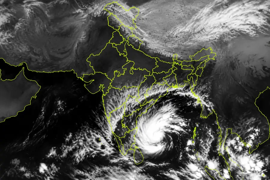
Will Cyclone Akvan strike Tamil Nadu or move towards Andhra Pradesh? With the storm's projected trajectory subject to conflicting forecasts, residents along the eastern coast are grappling with uncertainty about where it could eventually make landfall.
While the India Meteorological Department (IMD) has maintained that the system is likely to cross the Andhra Pradesh coast, private weather forecasters suggest the cyclone could instead make landfall somewhere between Chennai and Cuddalore.
The conflicting assessments have triggered confusion, particularly among residents in coastal Tamil Nadu, who are trying to understand the potential threat and whether they need to prepare for the cyclone's impact.
According to the IMD's assessment on Sunday, a depression over the southeast and adjoining southwest Bay of Bengal is likely to intensify into a severe cyclonic storm by Tuesday.
The system is expected to move towards the Andhra Pradesh coast around Thursday.
The weather department also released a projected trajectory indicating that the cyclone would travel along the Tamil Nadu coast before making landfall in Andhra Pradesh.
However, private weather enthusiasts have offered a different assessment, suggesting a possible southward shift in the system's path that could bring it towards the Tamil Nadu coastline.
Dr VR Durai of the Regional Meteorological Centre (RMC), Chennai, told DT Next that IMD scientists rely on multiple weather prediction models to assess a cyclone's movement and projected trajectory.
These include the Multi Model Ensemble (MME) model and several global weather forecasting models.
Durai said that both RMC and IMD scientists had forecast an Andhra Pradesh landfall for Cyclone Akvan.
However, the system is expected to pass around 150 km offshore from Chennai, meaning its outer bands could still influence the city.
As a result, Chennai could experience heavy rainfall on November 17 and 18, even if the cyclone does not make landfall along the Tamil Nadu coast.
Addressing the divergent forecasts circulating online, Durai said some private weather enthusiasts rely on AI-based prediction models that analyse the tracks and behaviour of previous cyclones.
Hemachandran, popularly known as Delta Weatherman, however, remained firm on his assessment that Akvan could make landfall along the Tamil Nadu coast, somewhere between Chennai and Cuddalore.
He said forecasts generated by Google's AI weather prediction model, the ECM AI model and the Multi-Model Ensemble model indicated the possibility of a Tamil Nadu landfall.
According to him, the projected trajectory had shown a southward shift, strengthening the possibility of the system moving towards the state's coastline.
Hemachandran also cautioned that a more reliable assessment of the landfall location would be possible around November 17, approximately 48 hours before the cyclone is expected to make landfall.
Amid the competing predictions, the Tamil Nadu government has urged residents not to rely on unofficial forecasts.
Revenue Administration and State Relief Commissioner B Chandra Mohan said the government had instructed the public and fishermen to follow only official weather bulletins issued by the IMD and the Tamil Nadu State Disaster Management Authority (TNSDMA).
He added that the Disaster Management Department would issue guidelines to television channels and newspapers on publishing forecasts made by private weather bloggers.
For now, the crucial question remains whether Akvan will head towards Andhra Pradesh as forecast by the IMD or take a southward turn towards Tamil Nadu.
Until the projected path becomes clearer, authorities have emphasised the importance of relying on verified weather updates rather than speculative predictions.
Cyclone Akvan latest updates: 10 key points
1. Current status: The depression over the southeast and adjoining southwest Bay of Bengal is moving north-northwestwards.
2. Cyclone formation: The IMD expects the system to intensify into a cyclonic storm on November 16.
3. Further intensification: It is likely to strengthen into a severe cyclonic storm on November 17.
4. Very severe cyclone: The system could intensify further into a very severe cyclonic storm by November 19.
5. Projected trajectory: The IMD expects Akvan to move northwestwards towards the Andhra Pradesh coast over the next two days.
6. Landfall uncertainty: The precise landfall location has not yet been established by the IMD. Private weather forecasters have suggested a possible southward shift towards Tamil Nadu.
7. Chennai rainfall: Chennai could experience rainfall depending on the cyclone's proximity to the coast and the movement of its outer rain bands.
8. Tamil Nadu rainfall alert: Heavy to very heavy rainfall is likely at isolated places in Tamil Nadu between November 18 and 19.
9. Andhra Pradesh rainfall: Coastal Andhra Pradesh and Yanam are likely to receive heavy to very heavy rainfall, with isolated extremely heavy rainfall on November 19 and 20.
10. Wind speed: By November 19, the system could pack sustained winds of 120-130 kmph, with gusts reaching 145 kmph, according to the IMD's November 15 forecast.
Published: 16 Nov 2026, 07:51 am IST


ABOUT THE AUTHOR

Related Topics
Disclaimer: Kindly avoid objectionable, derogatory, unlawful and lewd comments, while responding to reports. Such comments are punishable under cyber laws. Please keep away from personal attacks. The opinions expressed here are the personal opinions of readers and not that of Mathrubhumi.