
While the flow in Wayanad descended from around 2,000 metres to 100 metres, in Nepal it travelled from about 5,200 metres to 100 metres, giving it a hydraulic gradient roughly two-and-a-half times greater than that of Wayanad.
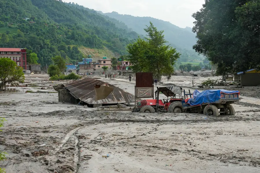
The disaster in Nepal holds important lessons for our small state of Kerala. What happened in Nepal can be seen as a "mega version" of the Mundakkai-Chooralmala disaster in Wayanad. The only difference is that instead of a landslide, Nepal witnessed an avalanche.
In Wayanad, the devastation was caused by a landslide followed by a debris flow through the river. In Nepal, it was an avalanche followed by a debris flow through the Lhende Khola. While the flow in Wayanad descended from around 2,000 metres to 100 metres, in Nepal it travelled from about 5,200 metres to 100 metres, giving it a hydraulic gradient roughly two-and-a-half times greater than that of Wayanad.
'Hungry water' and the threat from dams
Water stored in reservoirs built at high elevations contains enormous amounts of energy because of gravity. In hydroelectric projects, this water is brought down through penstock pipes to generate electricity. The water stored in Kerala's major dams, many of which are located at elevations of more than 1,000 feet, is what helps generate power and keep the state energised.
However, we saw the destructive force of this reservoir water when it was released during the 2018 floods. Those who witnessed the situation around Ranni along the Pamba River will remember how the water tore through the hillsides with tremendous force.
What we saw in Nepal was a much larger version of the same phenomenon. The difference was that instead of a man-made dam, there was a natural dam.
This is also why there is concern over the ageing Mullaperiyar dam, although its repeated strengthening provides some reassurance.
The scientific community refers to such energy-laden water stored behind dams as "hungry water". This water stores energy in the form of potential energy. When released, it can sweep away soil, mountainsides, trees and settlements in the downstream areas.
"Hungry water" released from a natural reservoir can scour and carry away sediment and rocks from the riverbed. If it encounters an obstruction along its path, the debris can accumulate and form another natural dam. As the water level rises, the dam can eventually breach, releasing another surge of "hungry water".
In steep river valleys with a high hydraulic gradient, this process can repeat several times, devastating downstream areas within minutes.
What actually happened in Nepal
The disaster occurred in the upper reaches of the Narayani river basin, a major tributary system of the Ganga. Parts of massive snow-covered mountains near the Tibetan border collapsed as an avalanche towards the source of the Lhende Khola river.
As the ice and rocks collided while rushing downhill, a significant amount of the ice melted into water. Rocks, soil and ice accumulated in the narrow river valley, creating a natural dam.
Within just 30 minutes, the water level behind the natural dam rose by around nine metres. Unable to withstand the increasing water pressure, the natural dam eventually breached, sending the stored water rushing downhill with enormous force.
The floodwater, which had travelled from an elevation of more than 5,000 metres through the Bhotekoshi and Trishuli rivers, swept away structures located on the river's floodplains, reclaiming the river's natural space.
Glaciers and the 'third pole'
Studies indicate that the world has lost around 900 billion tonnes of ice over the past five decades. After the Arctic and Antarctic regions, the Tibetan-Himalayan mountain ranges hold the world's largest reserves of freshwater in the form of ice. This is why the region is known as the "Third Pole".
These glaciers, located among some of the world's highest peaks, are essentially nature's "water bombs". When global warming, climate change and unscientific human interventions combine with the force of gravity, they can turn into major disasters.
The Himalayas were formed around 40-50 million years ago when the Indian and Eurasian tectonic plates collided, pushing up the floor of the ancient Tethys Sea. The mountain range continues to rise by around five millimetres a year.
The Himalayas lie in an earthquake-prone Zone 5. The latest disaster, coming after the devastating 2015 earthquake, underlines the fact that the Himalayan region remains unstable both beneath the Earth's surface and above it.
Lessons we need to learn
Protect floodplains: Natural flow channels in flood-prone river valleys may be used for agriculture, but settlements and major structures should be completely avoided in such areas.
Stop unscientific construction: Human interventions in hilly regions and along riverbanks must be substantially reduced.
Strengthen monitoring systems: Just as research and monitoring systems need to be strengthened in the Himalayan region, accurate real-time early warning systems must also be established across the Western Ghats.
At a time when climate change has become a reality, protecting people's lives and property will require strong policy decisions and strict laws.
(The author is a former head of the Hydrology Division at the National Centre for Earth Science Studies and a renowned geologist.
Published: 31 Aug 2026, 06:39 pm IST
Related Topics
Disclaimer: Kindly avoid objectionable, derogatory, unlawful and lewd comments, while responding to reports. Such comments are punishable under cyber laws. Please keep away from personal attacks. The opinions expressed here are the personal opinions of readers and not that of Mathrubhumi.
