A massive 7.7-magnitude earthquake struck Myanmar last Friday, leaving widespread devastation and a soaring death toll now exceeding 3,000. The quake, one of the most powerful in the country's history, originated near Mandalay, Myanmar’s second-largest city, and triggered an enormous surface rupture stretching approximately 500 kilometres.
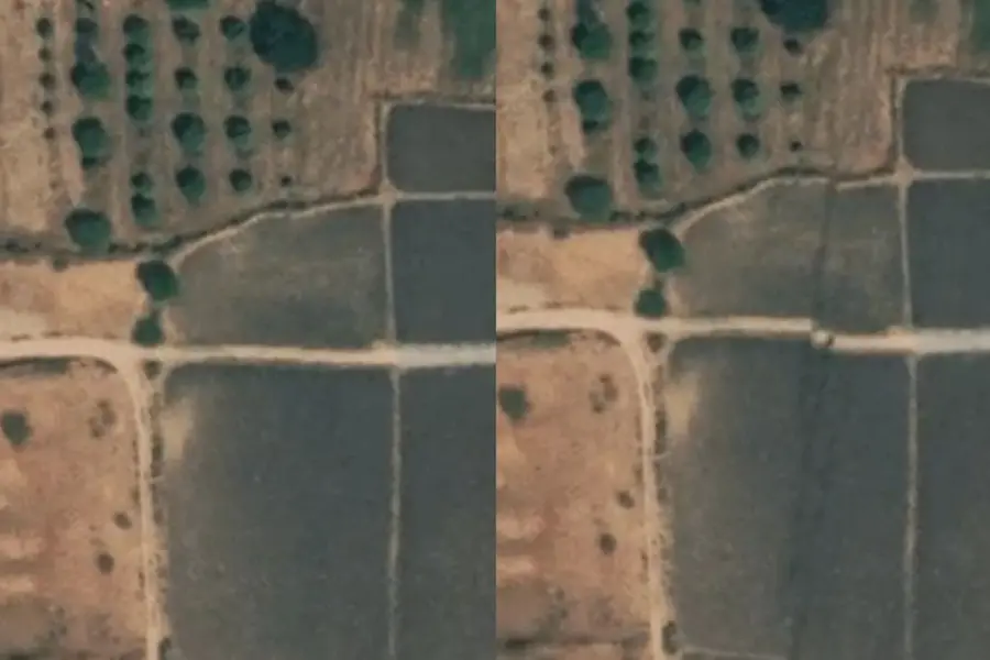
High-resolution satellite images from Maxar, processed by Nahel Belgherze, provide a detailed look at the scale of the geological upheaval. The data reveals fault slips reaching up to five metres, demonstrating the immense force that tore through the region.
Supershear rupture worsened devastation
The earthquake occurred along the Sagaing Fault, a major tectonic boundary, and exhibited supershear characteristics—where the rupture speed exceeds seismic waves. This rare phenomenon, often compared to a supersonic jet breaking the sound barrier, amplified the destruction by concentrating seismic energy, causing damage far beyond the immediate impact zone.
Entire neighbourhoods were razed, hospitals and buildings collapsed, and millions of residents were left without basic necessities. The quake’s force extended well beyond Myanmar, with significant damage reported in neighbouring countries, including Thailand, China, and Vietnam.
Ceasefire declared amid relief efforts
Myanmar’s military government has declared a temporary ceasefire until 22 April to facilitate relief operations. Armed resistance groups have also made similar declarations, allowing aid workers to reach affected areas. However, worsening weather conditions, including unseasonal rainfall, threaten to complicate rescue efforts and increase the risk of disease outbreaks.
The humanitarian crisis in Myanmar, already exacerbated by ongoing civil conflict, has intensified in the wake of this disaster. International relief efforts are underway, with satellite imagery playing a critical role in assessing damage and guiding aid distribution.
Fault slips near Mandalay highlight scale of disaster
The newly released satellite images reveal significant horizontal displacements in both east-west and north-south directions. The most severe fault slips were observed near Mandalay, an area densely populated with millions of residents. These findings underscore the devastating impact of the quake and the long road to recovery ahead.
Published: 04 Apr 2025, 04:31 pm IST
Related Topics
Disclaimer: Kindly avoid objectionable, derogatory, unlawful and lewd comments, while responding to reports. Such comments are punishable under cyber laws. Please keep away from personal attacks. The opinions expressed here are the personal opinions of readers and not that of Mathrubhumi.
