
Pakistan’s continued restrictions on Indian aircraft have forced airlines to take longer routes to Europe and North America. India is now exploring whether an alternative corridor through China’s Xinjiang region, potentially involving Hotan, could provide another westbound route.
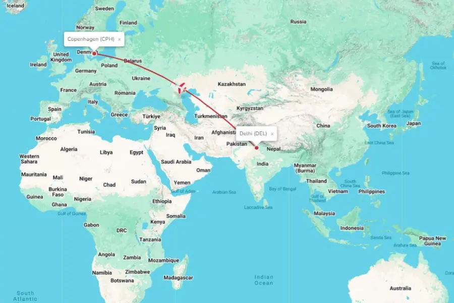
Pakistan’s continued airspace restrictions are forcing Indian airlines to take longer and more expensive routes to Europe and North America. Now, India is exploring a possible corridor over China’s Xinjiang region. But turning that idea into a practical flight path will not be easy.
For more than a year, Indian airlines flying west have had to take a long detour. Instead of flying directly across Pakistan towards Europe and North America, aircraft departing from cities such as Delhi and Mumbai have been heading south over the Arabian Sea before turning north-west. The reason is Pakistan’s continued ban on Indian aircraft using its airspace.
The result is more flying time, higher fuel consumption and greater operational complexity for Indian carriers.
Now, India is looking at another possibility, a route through China's Xinjiang region that could allow Indian aircraft to bypass Pakistan without making the long southern detour.
Civil Aviation Minister Ram Mohan Naidu recently said India and China are discussing the possibility of an air route over Hotan in Xinjiang. He said the Ministry of External Affairs is involved in the discussions, but there is no agreement or timeline yet. If such a route becomes possible, it could provide Indian airlines with an alternative westbound pathway. But there are several reasons why getting there will be complicated.
Why Indian aircraft are taking the long way
Airlines generally seek the most efficient routes between two destinations. Because the Earth is curved, the shortest path between two points often appears as a curved line on a flat map. These are known as great-circle routes. For many flights from northern India to Europe, the UK and parts of North America, the efficient path naturally runs north-west across Pakistan. That option disappeared in April 2025.
Pakistan closed its airspace to Indian-registered and Indian-operated aircraft following the Pahalgam terror attack. India subsequently imposed reciprocal restrictions on Pakistani aircraft. Pakistan has repeatedly extended its restriction. The latest notice extends the ban until October 24. For Indian airlines, this has meant finding longer routes around Pakistan.
Some flights have been diverted south over the Arabian Sea towards Oman before turning north-west. Depending on the destination, the additional flying time can range from roughly 45 minutes to several hours. For passengers, that means longer journeys. For airlines, it means something much more expensive.
Every extra hour costs money
A longer flight does not simply mean passengers spending more time in the aircraft. It means more fuel, greater aircraft utilisation, additional crew time and potentially more complicated scheduling.
Air India had estimated that the Pakistan airspace closure was costing the airline thousands of crores. The airline also reported significant increases in fuel consumption on affected routes, while some long-haul journeys became several hours longer. The effect is particularly significant on flights to destinations in Europe and North America. Some flights have also required technical fuel stops because of the additional distance.
That creates another operational problem, an aircraft and crew that spend more time completing one journey are less available for the next one. For airlines operating large international networks, these small increases can accumulate across hundreds of flights.
It is not only India that loses
There is another side to the airspace closure. Pakistan also loses revenue when international aircraft avoid its airspace. Airlines normally pay overflight charges for using a country's airspace. Pakistan's own figures have indicated billions of rupees in lost overflight revenue during the current restrictions. This is not the first time India and Pakistan have used airspace restrictions against each other.
Following the Balakot air strikes in 2019, Pakistan closed its airspace to civilian traffic. That closure eventually lasted several months and caused substantial additional costs for airlines.
The difference this time is the duration. The present restrictions have already lasted considerably longer, forcing airlines to adapt their networks and schedules rather than treating the disruption as a temporary event.
Why China has entered the picture
India's search for an alternative route has become more urgent because the southern option is no longer as straightforward as it once was. The wider airspace environment around West Asia has also changed. Following the outbreak of the Iran conflict in February 2026, several countries in the region closed or restricted their airspace. Although some restrictions have since changed, many international airlines continue to avoid parts of Iranian airspace or operate only along designated routes.
That has increased pressure on alternative corridors between Asia and Europe.
Before the latest disruptions, some Indian flights could use routes through Iran and Central Asia after avoiding Pakistan. With Iranian airspace becoming more complicated, the southern corridor through countries such as Oman, Saudi Arabia and Egypt has become increasingly important and more congested. For India, therefore, finding another route is not simply about saving a few minutes.
It is about creating route resilience.
The Hotan idea
This is where China's Xinjiang region enters the picture. The proposed route would involve Indian aircraft flying north from India, potentially towards the Ladakh region, entering Chinese airspace around Hotan and then heading west towards Central Asia before connecting with existing routes to Europe and other destinations. The exact routing has not been made public.
Indian authorities have only confirmed that discussions are taking place.
If an arrangement is eventually reached, destinations such as Central Asia, the Caucasus, northern Europe and parts of the UK could potentially benefit from a more direct routing than the current southern detour. But geography immediately presents a challenge. The mountains are a major problem. Xinjiang is not an easy region through which to route commercial aircraft.
The area around the proposed corridor contains some of the world's highest mountain ranges, with peaks exceeding 20,000 feet. For a passenger aircraft flying at cruising altitude, mountains at these elevations become an important safety consideration.
Consider what happens during a depressurisation.
Normally, an aircraft experiencing a loss of cabin pressure descends rapidly to an altitude where passengers can breathe safely, while emergency oxygen systems provide temporary support.
But when an aircraft is flying over extremely high terrain, it cannot simply descend vertically to a safe altitude. Pilots need carefully planned escape routes that allow the aircraft to descend while remaining clear of mountains. The same principle applies to an engine failure.
A twin-engine aircraft can continue flying on one engine, but its performance is reduced. Over high terrain, pilots and flight planners need to ensure that the aircraft has a safe descent path and sufficient terrain clearance. This makes the route much more complicated than simply drawing a line between two airports.
Where would an aircraft land in an emergency?
There is another question of diversion airports. Commercial aircraft operating long-haul routes need suitable airports that they can reach in an emergency.
The Hotan region has relatively few airports that could serve as practical alternatives for international aircraft, and foreign airlines have very limited experience operating through the area. That creates an additional layer of operational planning.
Before airlines can routinely use such a corridor, they would need to establish detailed procedures covering emergency diversions, navigation, communications, weather, terrain clearance and coordination with air traffic control. In aviation, the shortest route is not automatically the best route, it should also be safe, controllable and operationally reliable.
Then there is the China factor
The biggest challenge may not be geography at all but diplomacy. Under international aviation rules, countries have sovereignty over the airspace above their territory. Foreign airlines cannot simply decide to fly through another country's airspace because it happens to provide a shorter route. China would therefore have to approve and manage any such corridor and the proposed route lies in a particularly sensitive part of the country.
Xinjiang falls under China's Western Theatre Command, which has responsibility for China's western borders, including the area facing India. The region also sits close to one of the most sensitive territorial disputes between the two countries.
Between Ladakh and Hotan lies Aksai Chin, an area administered by China but claimed by India. That makes the proposed route more than an ordinary commercial aviation arrangement. The precise routing would matter enormously.
Could an aircraft fly over Aksai Chin?
This is one of the unanswered questions. A direct line between Leh and Hotan would cross territory that India claims but China administers.
Neither government has publicly explained how such a route would be structured, where the corridor would begin and end, or how air traffic control responsibilities would be managed. Those details would have to be addressed before airlines could treat the route as a dependable commercial option.
For India, this is therefore not simply a matter of asking China for permission to use a shorter flight path. It would require agreement on a piece of airspace located in a strategically sensitive border region.
Why the route still matters
Despite all these complications, the fact that India is exploring the option is significant. For airlines, the ideal situation is not necessarily to depend on one particular corridor forever. What matters is having multiple viable routing options. The Pakistan restriction has demonstrated what happens when an important geographical corridor suddenly becomes unavailable.
Flights have to be rerouted. Fuel costs increase. Aircraft utilisation changes, crew schedules become more complicated and passengers face longer journeys, obviously a second viable route could reduce some of that vulnerability. The new route could also become particularly valuable for destinations in Central Asia and Europe if it proves operationally feasible.
This is also about India's aviation ambitions
India's international aviation market is expanding rapidly, with Indian carriers adding aircraft and launching more international services. As the country's airlines become more global, the availability of efficient international air corridors becomes increasingly important. India's aviation strategy cannot depend only on airports and aircraft. It also depends on airspace access.
A modern aviation network requires predictable routes, sufficient capacity, reliable air traffic management and contingency options when geopolitical events disrupt established corridors.
The Hotan discussions therefore need to be viewed against this larger picture.
A solution, but not an immediate one
For now, the Hotan route remains an idea under discussion rather than an operational alternative. There is no confirmed agreement between India and China, no announced launch date and no published flight path.
Even if the two governments reach an understanding, airlines would still need to address the technical and operational challenges associated with high-altitude terrain, emergency diversion planning, air traffic control, navigation and safety procedures. The route would also have to make commercial sense. Aviation is ultimately an exercise in balancing distance, fuel, aircraft capability, safety, airspace charges, crew requirements and schedule reliability.
The bigger lesson from the Pakistan detour
The current situation highlights something that passengers rarely see when they look at a flight map. An airline route is not simply the shortest line between two cities.
Behind every international flight is a complex network of diplomatic permissions, air traffic control arrangements, terrain assessments, emergency procedures, fuel calculations and geopolitical considerations.
Pakistan's airspace restrictions have turned that complexity into a very visible cost for Indian airlines. India's interest in a route through Xinjiang shows how seriously the country is looking for alternatives.
Whether the Hotan corridor eventually becomes reality will depend as much on diplomacy and aviation safety as on geography. For now, Indian airlines will continue to take the longer way around as the search for a shorter, safer and more reliable path westward continues.
Published: 30 Sept 2026, 10:05 pm IST
ABOUT THE AUTHOR

Related Topics
Disclaimer: Kindly avoid objectionable, derogatory, unlawful and lewd comments, while responding to reports. Such comments are punishable under cyber laws. Please keep away from personal attacks. The opinions expressed here are the personal opinions of readers and not that of Mathrubhumi.