Amidst recent satellite setbacks, India must urgently bolster its own space-based reconnaissance.
For over a year now, since Operation Sindoor, India and Pakistan have appeared to be at peace. The guns fell silent, diplomats spoke, and a ceasefire held. On the surface, calm returned. But beneath that calm, something else has been quietly taking shape, and it has nothing to do with the border we can see.
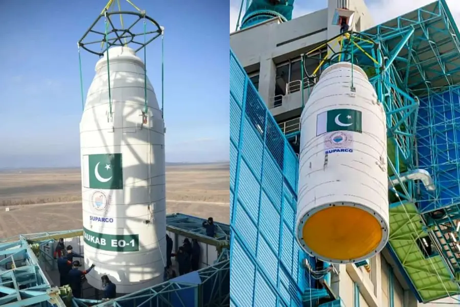
In the last 16 months, Pakistan has been building a constellation of surveillance satellites, one launch at a time, with each one capable of watching Indian soil from above. This is not guesswork. By studying open-source launch records, ThePrint found that between January 2025 and June 2026, Pakistan carried out six Earth-observation satellite launches. Six missions in just sixteen months.
To understand how big that is, consider this. From its founding in 1961 all the way to 2024, Pakistan's space agency, SUPARCO, managed only nine launches in total. It has now almost matched that lifetime record in a little over a year. Something fundamental has shifted.
So what are these satellites? On paper, they are Earth-observation platforms, built for agriculture, disaster management and civilian mapping. But here is the catch. Every Earth-observation satellite, by its very nature, can also spot military bases, track troop movements, count ships in a harbour and notice changes on the ground. The same camera that watches crops can watch a cantonment.
The launches came quickly. PAUSAT-1 went up on 14 January 2025 aboard a SpaceX rocket, followed just three days later by PRSC-EO1 on a Chinese Long March 2D. Then came PRSC-S2 in July, a direct China-Pakistan collaboration, and HS-1 in October. These weren't random launches. They came one after another, like building a secret sky network.
HS-1 deserves special attention because it is Pakistan's first hyperspectral satellite. An ordinary camera sees only red, green and blue — the colours our eyes know. A hyperspectral satellite captures hundreds of tiny colour bands invisible to us. Imagine it as a super detective that can sense hundreds of different colours instead of just three. This lets it read a "light fingerprint" for every object on the ground — telling what a material is made of, seeing through camouflage, and detecting changes a normal photo would miss. It doesn't just photograph the earth — it reads it.
In 2026, Pakistan added two more, both on Chinese rockets: PRSC-EO2 in February and PRSC-EO3 in April. And it is PRSC-EO3 that makes the picture truly sharp.
Most Earth-observation satellites use a "sun-synchronous" orbit, which gives steady lighting and broad coverage, passing over a region at the same time each day, ideal for a spy satellite. Most Pakistani satellites follow this pattern. But PRSC-EO3 does not. A US-based space analytics firm, COMSPOC, publicly flagged that it sits in an unusual 38-degree inclined orbit. In plain words, it gives up watching the whole world in exchange for passing over one narrow strip far more often. That strip, between roughly 20 and 40 degrees north latitude, is exactly where Pakistan, northern India and Jammu and Kashmir lie. This satellite is not built to watch the world. It is built to watch a specific region, and that region is us.
Put together, an analysis using the commercial imagery platforms Apollo Mapping and SkyFi shows that Pakistan's six satellites, along with a range of Chinese networks, can photograph Indian territory at least once every two days, roughly one pass every 48 hours.
The China connection cannot be ignored. Five of the six launches used Chinese rockets from Chinese facilities, and PRSC-S2 was a direct bilateral project. The help goes beyond hardware. Experts describe active intelligence-sharing between the two countries' space programmes. China's Yaogan series is the clearest example. The name means "remote sensing," and Beijing calls them civilian. Yet Western and Indian analysts have long seen Yaogan as the backbone of China's military reconnaissance fleet, roughly 140 satellites combining sharp optical cameras, radar that sees through clouds and darkness, and electronic eavesdropping. They already keep India under close, continuous watch. Now Pakistan has its own eyes to add on top. According to experts, this real-time sharing was visible during Operation Sindoor itself.
And here is the uncomfortable other half. While Pakistan was building its eyes in the sky, India was losing some of its own. In the same period, the country suffered three strategic satellite setbacks, including the recent loss of Anwesha, India's advanced hyperspectral satellite developed by DRDO, the very vision Pakistan now has through HS-1.
No nation can stop another from reaching for space. But India needs not stand still. The answer is to meet surveillance with surveillance, and information with sharper information. India must now look up and build even stronger eyes in the sky.
(Girish Linganna is an award-winning science communicator and a Defence, Aerospace & Geopolitical Analyst. He is the Managing Director of ADD Engineering Components India Pvt. Ltd., a subsidiary of ADD Engineering GmbH, Germany.)
Published: 09 Jun 2026, 06:43 pm IST
Disclaimer: Kindly avoid objectionable, derogatory, unlawful and lewd comments, while responding to reports. Such comments are punishable under cyber laws. Please keep away from personal attacks. The opinions expressed here are the personal opinions of readers and not that of Mathrubhumi.
