NISAR transmits first signal, begins tracking Earth’s movements
New Delhi: The joint NASA-ISRO Earth observation satellite, NISAR (NASA-ISRO Synthetic Aperture Radar), has successfully sent its first signals after being launched from Sriharikota. Mission controllers confirmed full acquisition of signals from the spacecraft, marking a key milestone for the mission.
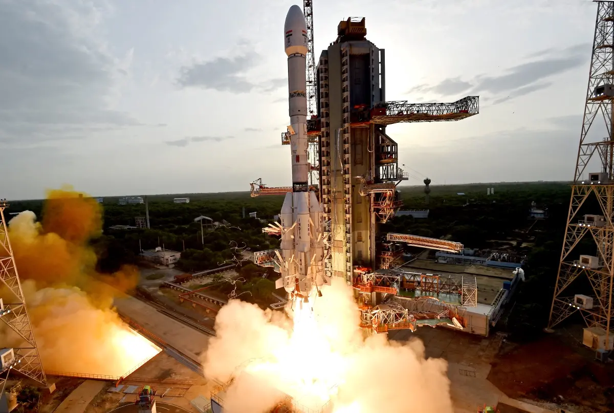
The satellite lifted off on Wednesday, July 30, at 5:40 pm IST, onboard an ISRO Geosynchronous Satellite Launch Vehicle (GSLV) rocket. About 20 minutes after the launch, ISRO’s ground team established communication with the satellite and confirmed it is working as expected.
Helping respond to disasters and monitor earth changes
NISAR will deliver high-resolution data from space to support scientists, communities, and policymakers. It is designed to help monitor agriculture, track infrastructure changes, and improve understanding of natural hazards like earthquakes, landslides, floods, hurricanes, and volcanic eruptions. The mission aims to help teams prepare for and respond to such events more effectively.
A key feature of the satellite is its ability to detect the movement of land and ice surfaces as small as a few centimetres. This can be crucial for monitoring areas at risk of natural disasters.
NISAR is part of a major collaboration between NASA and the Indian Space Research Organisation (ISRO). The mission reflects the growing space partnership between the United States and India, which was highlighted by President Donald Trump and Prime Minister Narendra Modi earlier this year.
The satellite orbits Earth at an altitude of 747 kilometres (464 miles) and will track changes on the planet using two advanced radar instruments.
Tracking ecosystems, crust movements and permafrost
NISAR will scan nearly all of Earth’s land and ice-covered areas twice every 12 days. It will collect data on forests, wetlands, permafrost, and even the planet’s frozen surfaces. Its radar systems are sensitive enough to detect even the smallest movements in the Earth’s crust, important for understanding how land shifts before and after earthquakes and landslides.
The satellite’s dual radars will also keep watch over regions of the southern polar area that are not often observed by other satellites.
First mission with dual radar systems in space
NISAR is the first space mission to carry both L-band and S-band radar instruments. These two systems are designed to capture different types of information.
The L-band radar is well-suited for tracking soil moisture, forest density, and the motion of land and ice surfaces. The S-band radar, on the other hand, is especially useful for monitoring changes in agriculture, grasslands, and infrastructure.
Together, the two radars will allow scientists to study how landscapes evolve and provide crucial data for managing natural resources and responding to environmental changes.