Africa bigger, West smaller: How a UN map vote will reshape global order
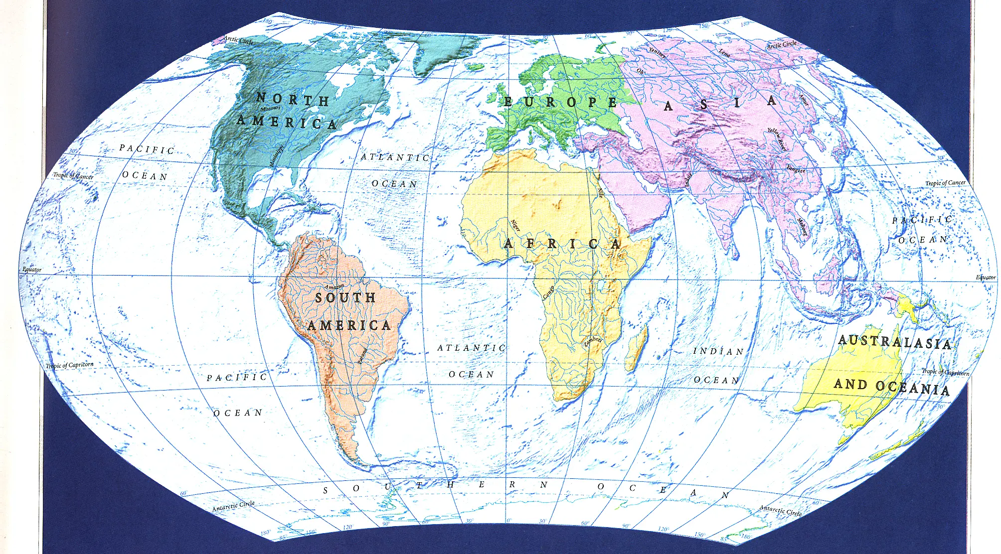
In a rare 164–1 vote that has quickly become a flashpoint in the culture wars at the United Nations, the General Assembly on Friday endorsed a new world map that shows Africa in its true relative size -- and, as a consequence, makes North America and Europe look smaller.
The United States cast the lone “no” vote, denouncing the move as an ideological distraction, while European capitals and most of the Global South hailed it as a long-overdue correction of a colonial-era distortion.
The resolution does not ban the familiar Mercator map, but it does mark a decisive political and symbolic shift: for the first time, the UN is explicitly promoting an alternative projection -- Equal Earth -- as the preferred standard for education, media and official communications whenever accurate area matters.
For supporters, it is a question of “cognitive justice” and de‑colonising how the world sees itself. For Washington, it is proof that the UN is losing its way.
What the vote actually did
The resolution, titled “Correct the Map: Rebalancing global cartographic representation and promoting equitable representation of the world’s regions, particularly Africa,” was introduced by Togo on behalf of the African Group and backed by the African Union. It passed with 164 votes in favour, one against (the United States) and six abstentions (Estonia, Georgia, Lithuania, Moldova, Serbia and Ukraine).
ALSO READ: India looks bigger: How UN’s Equal Earth map redraws the mental geography of power
Its core ask is technical but far-reaching: governments, schools, international organisations and technology companies are encouraged to use equal‑area projections such as Equal Earth when depicting relative sizes of countries and continents, and to teach students the limitations of any flat map in representing a spherical planet.
The Mercator projection -- designed in 1569 for maritime navigation -- is not outlawed, but the resolution argues its continued dominance has contributed to the “symbolic minimization” of Africa and perpetuated an unbalanced view of the world.
Under Equal Earth, Africa appears dramatically larger, while Greenland, Canada, the United States, Russia and much of Europe shrink to their true proportional size. In Mercator, Greenland can look roughly the same size as Africa; in reality, Africa is about 14 times larger.
Why Africa pushed so hard
For African diplomats, this is not just about cartography. It is about how generations have internalised a visual hierarchy that places Europe and North America at the centre and top of the world, while shrinking the continent that is home to 1.4 billion people and vast resources.
ALSO READ: Can India stop a hazardous asteroid? Expert outlines why preparedness is crucial
“Maps shape our understanding of the world. They guide education, nourish the imagination, and influence collective perceptions,” Togo’s Foreign Minister Robert Dussey told the General Assembly before the vote. “A fair map does not change the geography of the world, it changes how we see the world.”
The African Union formally endorsed the #CorrectTheMap campaign in 2025, urging its 54 member states to adopt Equal Earth in schools and public communications. Advocates argue that the Mercator map has subtly undermined perceptions of Africa’s resources, population and investment potential, reinforcing a Eurocentric and colonial worldview.
“A map is never neutral,” Dussey said in a UN briefing. “It shapes perceptions and influences how the roles of peoples and continents in the world are understood.”
Washington’s lone stand: “Barnacles on our work”
The United States opposed the resolution from the outset. In a sharp intervention, US representative Yaryna Ferencevych called the initiative part of a “much larger and more radical ideological project” and warned that such moves are “the reason this institution is losing its credibility.”
She singled out the resolution’s references to reparations and “cognitive justice”, arguing that the UN should focus on “genuine problems concerning peace, prosperity or good relations” instead of “debating map projects from the 16th century.”
ALSO READ: India officially maps 27 Arunachal sites to counter China's ‘preposterous’ renaming spree
The language was strikingly confrontational, even by current US–UN standards. Washington has in recent months also clashed with the Assembly over resolutions on the transatlantic slave trade and other historical justice issues, framing them as distractions from security and economic priorities.
Europe’s split: France leads, East raises borders concerns
Europe largely backed the resolution, but with caveats. France moved early: hours before the vote, Foreign Minister Jean‑Noël Barrot announced that Paris would abandon the Mercator projection in its official world maps, aligning with the African Union’s push. That means France itself -- like the US and Russia -- will appear smaller relative to equatorial countries.
The European Union supported the text but stressed that the measure applies only to relative size, not to sovereignty, territorial status or internationally recognised borders. Ireland, speaking for the bloc, said EU support did not constitute an endorsement of the specific maps displayed on the Equal Earth website.
Ukraine, while supporting efforts to correct historical distortions affecting Africa and the Global South, warned that some Equal Earth maps depict Ukrainian territory occupied by Russia in ways that could create ambiguity. Its representative cautioned that endorsing the projection without safeguards could open a “Pandora’s box” on disputed borders. Ukraine, along with Estonia, Georgia, Lithuania, Moldova and Serbia, ultimately abstained.
What Equal Earth changes -- and what it doesn’t
Equal Earth, developed in 2018 by cartographers Bojan Šavrič, Bernhard Jenny and Tom Patterson, is an equal‑area projection: it preserves the relative size of landmasses but sacrifices perfect shape and straight‑line compass directions. Mercator, by contrast, preserves direction (vital for navigation) but wildly distorts area as you move away from the Equator.
No flat map can perfectly represent a sphere; every projection trades off between area, shape, distance and direction. The UN resolution acknowledges this, insisting only that where relative size matters — in classrooms, news graphics, development reports — equal‑area maps should be the default.
In practical terms:
- Africa, South Asia, Southeast Asia and much of Latin America look larger and more proportionate.
- The United States, Canada, Russia and Europe look smaller, closer to their true share of the planet’s land area.
- Greenland and Antarctica cease to dominate the visual field; Greenland no longer appears comparable to Africa.
Google, which long used a Mercator‑based map, shifted in 2018 to showing the Earth as a globe when zoomed out on desktop, noting that “Greenland’s projection is no longer the size of Africa.” Some school districts, including Boston Public Schools, have already moved to equal‑area maps as part of efforts to “decolonise the curriculum.”
How this reshapes the world order
The resolution is non‑binding; no country is forced to change its wall maps or app defaults. But its political and symbolic weight is significant, and its implications for the world order are already unfolding along several axes.
1. A new front in the decolonisation debate: By framing map reform as “cognitive justice” and “memorial reparation,” the resolution ties cartography to broader demands for historical accountability, from slavery reparations to restitution of artefacts. For many Global South capitals, correcting the map is part of dismantling colonial narratives embedded in everyday tools -- textbooks, news graphics, corporate logos.
That aligns with a wider African and Global South push to reframe international institutions around equity, not just power. The near‑unanimous vote (164–1) signals that, on cultural and historical issues, Washington is increasingly isolated even among traditional partners.
2. US credibility and soft power under strain: Washington’s lone “no” vote reinforces a narrative that the US sees the UN as a venue to be managed, not a forum for collective norm‑setting. US diplomats argue the body should focus on hard security, great‑power competition and economic issues; much of the rest of the world sees historical justice, climate finance and representation as equally existential.
The map vote becomes a shorthand: when the UN debates “16th‑century map projects,” is that trivial ideology, or a legitimate effort to correct centuries of visual bias? The answer depends on where you sit -- and that split itself is a feature of the emerging multipolar order.
3. Education, media and the next generation’s mental map: Over time, the resolution’s biggest impact may be generational. If major education systems, broadcasters and tech platforms adopt Equal Earth as the default for “size‑sensitive” maps, children growing up in the 2030s will internalise a different mental image of the world: a larger Africa, a less dominant North Atlantic, a more balanced Global South.
That matters for everything from development policy to business strategy. As Kenyan geographer Kioko Kendo told the BBC, "Maps are more than just navigational tools; they influence how regions are viewed politically and economically." A continent that looks bigger is harder to dismiss as marginal.
4. Tech platforms and the battle over default maps: The resolution explicitly urges major digital map providers to discuss the issue with governments and adopt more accurate representations. That sets up a new pressure point for companies like Google, Apple and OpenStreetMap contributors: as schools and governments shift to Equal Earth, pressure will grow to make equal‑area options more visible, or even default, in certain contexts.
For platforms, the choice is not just technical; it is geopolitical. Sticking with Mercator‑style defaults may be read as siding with the US position; embracing Equal Earth more fully may be seen as aligning with the Global South and Europe.
5. Borders, sovereignty and the “Pandora’s box” worry: Ukraine’s and the EU’s border caveats highlight another tension: in a world of contested frontiers, any change in map style can be weaponised. Equal Earth does not alter borders, but its different visual emphasis can be exploited in propaganda — for example, to downplay or exaggerate the size of occupied territories.
Expect future UN debates to include sharper language ensuring that cartographic reforms do not undermine recognition of internationally recognised borders — a small but telling sign of how map politics now intersects with hard security concerns.
What happens next
In the short term, the resolution will:
- Encourage member states to review school curricula, official publications and public communications for map use.
- Prompt some governments -- following France’s lead -- to announce transitions away from Mercator in official contexts.
- Give advocacy groups, educators and media outlets a clear UN‑backed reference point to demand change from publishers and tech firms.
In the longer term, the “Correct the Map” vote may be remembered less for the specific projection it promotes and more for what it reveals about the shifting world order: a Global South confident enough to challenge centuries‑old norms, a Europe willing to compromise some visual prestige for equity, and a United States increasingly willing to stand alone when it sees the UN drifting into what it calls ideological terrain.
As Togo’s Dussey put it: “A fair world begins with a fair map.” Whether that fair map leads to a fairer world order is now a political question, not just a cartographic one.