NISAR: ISRO and NASA's $1.5 billion eye in the sky with a bold mission
The NASA-ISRO Synthetic Aperture Radar (NISAR) mission, slated for launch in May 2025, is a shining example of how India and the United States are joining hands to unlock the secrets of our planet. This ambitious project, led by the Indian Space Research Organisation (ISRO) and the National Aeronautics and Space Administration (NASA), is set to revolutionise Earth observation with its cutting-edge radar technology.
NISAR is not just a satellite; it is a beacon of hope for tackling climate change, managing disasters, and ensuring food security. For India, it is a proud moment, showcasing our growing strength in space and our ability to partner with the world’s top space agency to address global challenges.
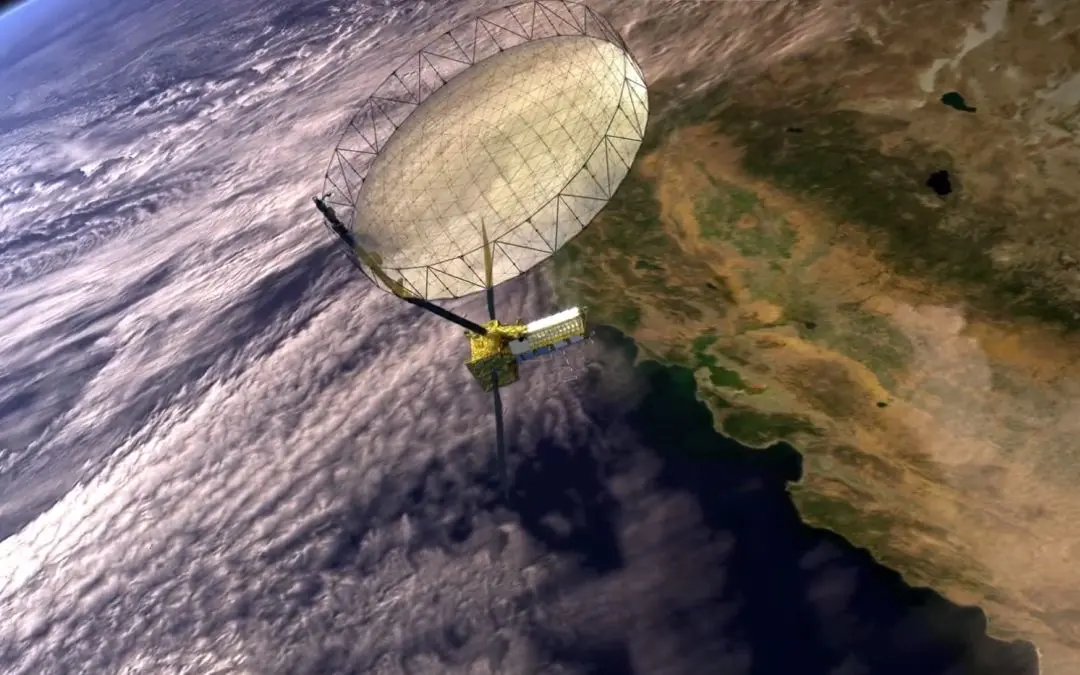
NISAR's core strength lies in its ability to map the entire globe every 12 days using dual-frequency Synthetic Aperture Radar (SAR). Unlike traditional satellites that struggle with clouds or darkness, NISAR's radar can work in any weather and at any time. This makes it a powerful tool for studying everything from melting glaciers to earthquake-prone zones.
The mission uses two radar bands: the L-band, provided by NASA, and the S-band, contributed by ISRO. The L-band, with a 24-centimeter wavelength, can penetrate deep into forests, soil, and even ice, making it ideal for studying ecosystems, soil moisture, and glacier movements. The S-band, with a shorter 12-centimeter wavelength, is sensitive to surface changes, perfect for monitoring urban areas, infrastructure, and small shifts in the Earth's crust.
Together, these bands give NISAR unmatched versatility, allowing it to detect changes as small as one centimeter.
NASA's role in NISAR is critical. Besides providing the L-band radar, NASA is contributing a high-rate communication subsystem for sending science data back to Earth, GPS receivers for precise positioning, and a payload data subsystem to manage the massive amounts of information the satellite will collect.
NASA's expertise in radar technology and data processing is a cornerstone of the mission, with its Jet Propulsion Laboratory (JPL) leading the development of the Integrated Radar Instrument Structure (IRIS), which holds the SAR payloads.
NASA's investment, estimated to be over US$1 billion, reflects the mission's importance and the agency's commitment to advancing Earth science. Their L-band radar will help scientists understand how forests store carbon, how glaciers are shrinking, and how soil moisture affects agriculture -- key pieces of the climate change puzzle.
ISRO's contributions are equally vital, showcasing India's technological prowess. ISRO is providing the S-band radar, which complements NASA's L-band by focusing on surface-level changes. This radar is crucial for tracking urban expansion, monitoring infrastructure, and detecting early signs of earthquakes or landslides.
ISRO is also responsible for the spacecraft bus, which houses all the satellite’s systems, ensuring it operates smoothly in orbit. Additionally, ISRO is handling the data transmission system, spacecraft integration, and testing, as well as the launch itself, using its reliable Geosynchronous Satellite Launch Vehicle Mark II (GSLV Mk II) from Satish Dhawan Space Centre in Sriharikota.
ISRO's role extends to on-orbit operations, ensuring the satellite functions perfectly throughout its mission. This end-to-end involvement highlights India’s ability to manage complex space projects.
The NISAR mission, with a total cost of about US$1.5 billion (roughly Rs 12,500 crore), is one of the most expensive Earth-imaging satellites ever built. While the exact financial split between NASA and ISRO is not public, both agencies are sharing the burden based on their technical contributions.
The mission's 12-meter radar antenna, which unfolds in space, enables a 240-kilometer imaging swath, covering nearly the entire Earth, with only about 1% of high-latitude areas unmapped due to orbit limitations. This global coverage, combined with the L-band and S-band radars, will provide data that is both detailed and consistent, helping scientists and policymakers make better decisions.
For India, NISAR is a milestone that goes beyond science. It shows the world that ISRO can deliver on high-stakes missions alongside a giant like NASA. The data from NISAR will be a lifeline for India, where millions depend on agriculture and face threats from floods, droughts, and earthquakes.
By mapping soil moisture, NISAR will help farmers use water wisely, boosting crop yields in dry regions. By monitoring tectonic plates, it will give early warnings for earthquakes, potentially saving countless lives.
For a country grappling with climate change, NISAR's insights into forests, wetlands, and coastlines will guide efforts to protect the environment and build sustainable cities.
The journey to May 2025 has not been without hurdles. Technical challenges, like repairs to the radar antenna and orbital constraints, delayed earlier launch plans from 2024 and early 2025. These setbacks show how carefully ISRO and NASA are working to ensure NISAR's success.
The collaboration itself is a model for the future, with both agencies sharing knowledge and technology. For India, this partnership is a chance to learn from NASA's expertise while showcasing our own innovations, like the S-band radar and the GSLV Mk II. It is a win-win that strengthens India's position in global space exploration.
NISAR's impact will be felt far beyond India and the US. Its data will be freely available to scientists worldwide, fostering global cooperation on issues like climate change and disaster management. For Indian students, NISAR is an inspiration -- a reminder that they too can dream of building satellites that change the world.